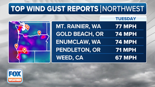
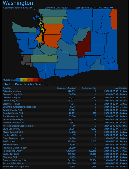
A massive bomb cyclone slammed into the Pacific Northwest on Tuesday night, unleashing torrential rains and tropical storm-like wind gusts up to 77 mph for certain areas. More than 600,000 customers across western Washington state are without power on Wednesday morning.
FOX Forecast Center said the powerful atmospheric river, coupled with a bomb cyclone, will unleash heavy rains and high winds across the area through Saturday.
A look at the bomb cyclone responsible for widespread power outages across the Pacific Northwest this morning. #CAwx #ORwx #WAwx pic.twitter.com/FY6OYOrfhS
— MyRadar Weather (@MyRadarWX) November 20, 2024
"The two storms are powering the event, the first of which is a powerful bomb cyclone. The strength of the low has kicked up strong winds up and down the coast, which have caused power outages and some damage," Fox Forecast Center explained.
Early Wednesday, data from Poweroutage.US showed that over 600,000 power customers across Washington State had no power. The bulk of the outages were in King County and Snohomish County.
FOX Forecast Center noted, "Measurements showed the storm dropped 66 millibars in pressure in 24 hours, eventually becoming a storm with a central pressure of 943 millibars - on par with a major Category 4 hurricane," adding, "It easily qualified for the title of "bomb cyclone," given when a storm strengthens about 24 millibars in 24 hours."
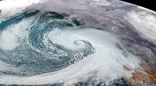
Satellite imagery shows the cyclone formation of the storm as it slammed into the Pacific Northwest overnight.
An incredible view of the 'bomb cyclone' strengthening and approaching the Pacific Northwest. pic.twitter.com/UeKyd0VA0z
— CIRA (@CIRA_CSU) November 20, 2024
Wind damage has been reported across the Seattle metro area.
This is what the effects of an atmospheric bomb cyclone — off the coast of Washington — look like in Bellevue.
— Jason Rantz on KTTH Radio (@jasonrantz) November 20, 2024
pic.twitter.com/GmfMwfHvgy
We have confirmed reports of trees down in Issaquah, Washington from the bomb cyclone, with power lines also taken out in the process.
— Category Six (@CategorySixWX) November 20, 2024
The storm has provided wind speeds of up to 70 MPH, with pressure being around 940-945 mb, which is the standard for a Category 4 hurricane. pic.twitter.com/IXYh9NuB1h
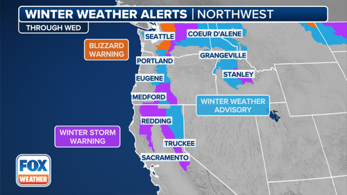
Life-threatening blizzard warnings have been posted at higher altitudes.
On the other side of the country, the season's first accumulating snowfall will be observed in higher altitudes across the Northeast.
Same map this morning even more bullish on the @" plus snows... pic.twitter.com/9nfvGrRzcL
— Jim Cantore (@JimCantore) November 20, 2024
The climate continues to change. Here comes winter.
Source link


