
A potentially historic winter storm is set to slam the Mid-Atlantic and Northeast beginning Sunday, bringing heavy snow, damaging winds, and coastal flooding.
As of Sunday morning, 35 million people are under Blizzard Warning alerts from the Mid-Atlantic through New England, according to a post on X from the National Weather Service Prediction Center.
Meteorologists are already labeling the nor'easter as potentially historic and warn it could be the most intense blizzard to hit the Mid-Atlantic and Northeast in a decade.
"IT" HAS THAT LOOK!!!!
— Mike Masco (@MikeMasco) February 22, 2026
Simulation satellite shows the PERFECT phase of this storm later today. A total occluded eye structure vertically stacked will support one HELL of a snow band ripping snow at 4-5" per hour for hours. If this band is fully into NYC we are going to 18+ inches… pic.twitter.com/k20obmsxAJ
⚠️We are continuing to track what is looking to be a historic winter storm for the Northeastern US. Heavy Rates, high gusts, and better consensus within models. This is not a storm to underestimate for SUN PM - MON!
— BAM Weather (@bam_weather) February 21, 2026
We will be doing a client live for the area at 7PM-ET! If you… pic.twitter.com/81AWSqqoAO
Potentially the worst blizzard in a decade is forecast to strike the northeast on Sunday into Monday. A historic snowstorm is forecast to bury Philadelphia, New York City, and Boston with potentially up to two feet of snow. Powerful 60-70 MPH wind gusts could cause widespread… pic.twitter.com/wlfWDKJ7mF
— Dylan Federico (@DylanFedericoWX) February 21, 2026
The 21z RAP is just a few inches short of producing the biggest snowfall of ALL TIME in the Wilkes-Barre/Scranton Area.
— Mark Margavage (@MeteoMark) February 21, 2026
The record is 27.2" in March 2017#wxtwitter #wxX #NEPA #BlizzardOf2026 pic.twitter.com/DzqIa9MFTq
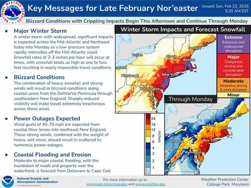
Snowfall forecasts are already pointing to a high-impact setup along large stretches of the I-95 corridor, from the Washington, D.C., area to Baltimore, Philadelphia, New York City, and Boston, where significant accumulations are possible.

In the Tri-State region, some forecasts suggest localized totals could reach upwards of 2 feet, likely sparking major travel disruptions from the I-95 corridor to air travel.

"DHS suspends TSA PreCheck & Global Entry over shutdown. Millions who paid for faster security now stuck in regular lines—while a historic blizzard cancels 7,000+ flights in the Northeast," Fox News reporter Lucas Tomlinson wrote on X.

Related:
The storm's setup is similar to the 2016 blizzard that blanketed Washington, D.C., Baltimore, and New York City with up to 2 feet of snow in some areas.


